Welcome to
Smart About Water
A place to understand approaches to water-resource management in the Truckee Meadows.


Conservation Works!
Reducing Water Waste, Preventing Leaks and Saving Energy
Conservation programs for people living in the Truckee Meadows has been in place since the mid-1980s and has proven to provide multi-faceted benefits. In fact, per capita consumption of water today is about the same as it was 35 years ago in the Reno/Sparks metropolitan area.
With water metering, distributed irrigation through Assigned-Day Watering and effective water resource management strategies, Truckee Meadows Water Authority (TMWA) has a solid blueprint to remain resilient to northern Nevada’s semi-arid climate and fluctuating winter snowpacks for decades to come.
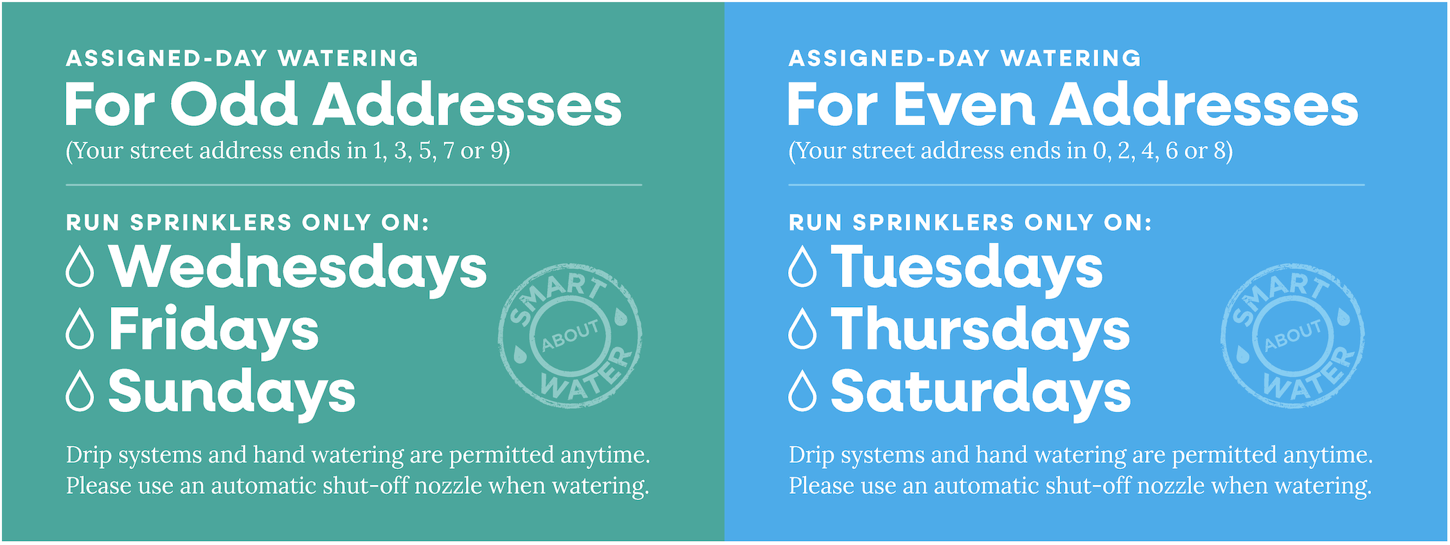
Assigned-Day Watering for Sprinkler Irrigation
Assigned-day watering is the community’s standard ethic for sprinkler irrigation throughout the year. It’s all based on the last number of the street address, which determines the following watering days schedule (print out reminder below). Everyone gets three days to run sprinklers:
- Odd addresses (1, 3, 5, 7, 9): Wednesdays, Fridays, Sundays
- Even addresses (0, 2, 4, 6, 8): Tuesdays, Thursdays, Saturdays
- Mondays: Rest day for the system
Note: Drip irrigation and hand watering are always permitted.
Smart Meters: Preventing Leaks Has Never Been Easier
With online account access, TMWA customers can also reduce water waste by setting-up Leak Alerts through the customer profile settings. Additionally with Smart Meter access, the portal provides near real time water usage to better understand ways to save water. For a step-by-step video tutorial to set-up an online account to establish leak alerts, go to tmwa.com/ami-how-to.
Saving Energy Helps Keep Customer Rates Stable
By spreading out demand and preventing waste, managed water use help reduce the energy required to treat and distribute drinking water across over a 170-square miles service area. Since pumping and filtration are energy-intensive, lower demand directly cuts electricity use which is one of Truckee Meadows Water Authority’s largest variable costs.
Truckee River and Tahoe Basins: Daily Water Update (click to flip!)
Daily SNOTEL Basin Index
Year-to-date indexes represent % of normal snow water equivalent compared to median value on this day for the 1981-2010 period.
This provisional data is provided from the California/Nevada SNOTEL Snow/Precipitation Update Report by the Natural Resources Conversation Service, and is subject to revision. Null percentages mean there is no measurable snowpack on that day.
Current Truckee River Flow
A key location where Truckee River flows are measured (in cubic feet per second or cfs) is near the California-Nevada state line, at the USGS Farad gaging station. This is the gaging station where required rates of flow are measured.
From March through September the required rate of flow is set for 500 cfs, and between October and February required rate of flow is 400 cfs. Flow rates are managed by the Federal Water Master and all data is provided by the United States Geological Survey.
For responsible recreational enthusiasts who monitor these flows, this map outlines all access points, features, diversions and portage options along the Truckee River from Truckee, CA to Tracy, NV.
Upstream Water Storage
Volume of water is measured in Acre Feet (AF). While many stakeholders also store water upstream, information shown here only reflects the upstream reserves held by Truckee Meadows Water Authority.
Water stored by TMWA is updated daily:
| Boca Reservoir | 64 Acre Feet |
| Donner Lake | 8,549 Acre Feet |
| Independence Lake | 16,884 Acre Feet |
| Prosser Reservoir | 0 Acre Feet |
| Stampede Reservoir | 16,088 Acre Feet |
| Lake Tahoe | 0 Acre Feet |
-
Current Lake Tahoe Level
The Dam at Tahoe City controls the amount of water released into the Truckee River. It can retain 6.1 feet of Lake Tahoe, or at maximum 744,600 acre feet of water. This maximum volume is met when water behind the dam reaches an elevation of 6229.10 feet.
Water Treatment Plant Production
Water from the Truckee Meadows is treated at two locations: the Chalk Bluff Treatment Plant in northwest Reno and the Glendale Water Treatment Plant in Sparks. Treatment plant output varies by season, as peak summertime customer demand can be as much as 4 times typical wintertime customer demand.
Many residents in the region are also served by groundwater wells.
Hydroelectric Production
The Truckee River is an excellent source of hydroelectric power. In fact, Fleish, Verdi and Washoe hydroelectric power plants produce an average of 50,000 kWh per year. This clean energy offsets the operational power costs for Truckee Meadows Water Authority and is a key contributing factor for keeping water rates as low as possible for customers. Benefits to the environment are sizable as well. Every day that the hydroelectric plants run at full capacity, over 90,500 pounds of CO2 emissions are effectively eliminated from our atmosphere.
Participate and Learn
May 2026
Wednesday, May 27 Sprinkler Maintenance Made Easy (for sprinklers only!)
5:30 p.m. - 6:30 p.m. at 1355 Capitol Blvd.
Get introduced to the basic concepts of operating, maintaining and repairing a typical residential sprinkler system.
Attendees must be a minimum of 10 years of age.
Please click HERE to RSVP at least 24 hours prior.
Friday-Sunday, 5/20-30, Reno River Festival
Idlewild Park
Saturday, May 30 Gardening Workshop
10:00 a.m. at Lake Park
Hosted by OneTruckeeRiver
June 2026
Wednesday, June 3 Verdi Hydroelectric Power Plant Tour
10 a.m. - 11 a.m. at Verdi Hyrdoelectric Power Plant, 0 Powerhouse Road
Customers are invited to tour the Verdi Hydroelectric Power Plant, which has been producing clean, renewable energy for 100 years. The tours are open to all TMWA customers. Each tour is limited to 20 people.
Please click HERE to RSVP at least 24 hours prior.
Wednesday, June 10 Verdi Hydroelectric Power Plant Tour
10 a.m. - 11 a.m. at Verdi Hyrdoelectric Power Plant, 0 Powerhouse Road
Customers are invited to tour the Verdi Hydroelectric Power Plant, which has been producing clean, renewable energy for 100 years. The tours are open to all TMWA customers. Each tour is limited to 20 people.
Please click HERE to RSVP at least 24 hours prior.
Saturday, June 13 Verdi Hydroelectric Power Plant Tour
10 a.m. - 11 a.m. at Verdi Hyrdoelectric Power Plant, 0 Powerhouse Road
Customers are invited to tour the Verdi Hydroelectric Power Plant, which has been producing clean, renewable energy for 100 years. The tours are open to all TMWA customers. Each tour is limited to 20 people.
Please click HERE to RSVP at least 24 hours prior.
Wednesday, June 17 Verdi Hydroelectric Power Plant Tour
2 p.m. - 3 p.m. at Verdi Hyrdoelectric Power Plant, 0 Powerhouse Road
Customers are invited to tour the Verdi Hydroelectric Power Plant, which has been producing clean, renewable energy for 100 years. The tours are open to all TMWA customers. Each tour is limited to 20 people.
Please click HERE to RSVP at least 24 hours prior.
Wednesday, June 24 Verdi Hydroelectric Power Plant Tour
2:00 - 3:00 p.m. at Verdi Hyrdoelectric Power Plant, 0 Powerhouse Road
Customers are invited to tour the Verdi Hydroelectric Power Plant, which has been producing clean, renewable energy for 100 years. The tours are open to all TMWA customers. Each tour is limited to 20 people.
Please click HERE to RSVP at least 24 hours prior.
September 2026
Tuesday, September 1 Chalk Bluff Water Treatment Plant Tour
3:00 - 4:00 p.m. at Chalk Bluff Water Treatment Plant
Tour with experts who will explain the water treatment and distribution processes, as well as discuss current challenges and answer your questions. Each session is limited to 20 people.
Please click HERE to RSVP at least 24 hours prior.
Tuesday, September 8 Chalk Bluff Water Treatment Plant Tour
1:00 - 2:00 p.m. at Chalk Bluff Water Treatment Plant
Tour with experts who will explain the water treatment and distribution processes, as well as discuss current challenges and answer your questions. Each session is limited to 20 people.
Please click HERE to RSVP at least 24 hours prior.
Tuesday, September 15 Chalk Bluff Water Treatment Plant Tour
10:00 a.m. - 11:00 p.m. at Chalk Bluff Water Treatment Plant
Tour with experts who will explain the water treatment and distribution processes, as well as discuss current challenges and answer your questions. Each session is limited to 20 people.
Please click HERE to RSVP at least 24 hours prior.
Tuesday, September 22 Chalk Bluff Water Treatment Plant Tour
1:00 - 2:00 p.m. at Chalk Bluff Water Treatment Plant
Tour with experts who will explain the water treatment and distribution processes, as well as discuss current challenges and answer your questions. Each session is limited to 20 people.
Please click HERE to RSVP at least 24 hours prior.
Saturday, September 26 Chalk Bluff Water Treatment Plant Tour
10:00 a.m. - 11:00 a.m. at Chalk Bluff Water Treatment Plant
Tour with experts who will explain the water treatment and distribution processes, as well as discuss current challenges and answer your questions. Each session is limited to 20 people.
Please click HERE to RSVP at least 24 hours prior.
October 2026
Wednesday, October 7 Winterize Your Irrigation System (in-person)
5:30 p.m. - 6:30 p.m. at 1355 Captial Blvd.
Prepare your irrigation system for the cold. This workshop is designed to help equip you with the knowledge and skills needed to properly winterize a residential irrigation system.
Please click HERE to RSVP at least 24 hours prior.
Wednesday, October 14 Winterize Your Irrigation System (virtual)
5:30 p.m. - 6:30 p.m. on Zoom
Prepare your irrigation system for the cold. This workshop is designed to help equip you with the knowledge and skills needed to properly winterize a residential irrigation system.
Join the webinar: https://tmwa.zoom.us/j/84043366205